Plug for www.huntingGPSmaps.com

Big Fin

Administrator
Staff member
Joined
Dec 27, 2000
Messages
16,581
Location
Bozeman, MT
As many of you know, I have been using the map chips from www.huntingGPSmaps.com for the last three seasons. Not because I was paid to use them, but because they are one thing that has changed my hunting more than anything in the last five years.

So many times I had wondered if I was on public or private. I had often thought about applying for areas with challenging access that are much easier to draw, but did not want to accidentally trespass. A few times I have been challenged by landowners or their agents as to me being on private property, but did not have the technology to verify my claims that I was on public.

All those problems were solved with this product. I now apply in easier-to-draw areas. I hunt in those areas with little worry of trespass. All resulting in more/better hunting experiences for me.

http://www.huntinggpsmaps.com/

The link above will take you to their site where you can watch some of their videos and look at some of their products. I am sure you will find them very useful for your hunting.

You will probably hear me taking about and promoting them even more as we go forward. You will find their links on many pages of the site.

Great product by some great guys. Made right here in Montana.
 
I have also used them for the last three years. Invaluable in the field hunting and while I am working.
 
I have been thinking about buying a chip for my gps unit with Idaho's info. A friend of mine swears by this chip that it is worth every dollar. thanks for the plug Fin.
 
I hate spending money on gadgets but this database was the best buy I made this year. In addition to the private land it has contour maps and trails. It beats the hell out of carrying around a bunch of maps trying to figure out whose land you are on.
 
I have been thinking about buying a chip for my gps unit with Idaho's info. A friend of mine swears by this chip that it is worth every dollar. thanks for the plug Fin.

I have the Idaho chip with every landowner's name. It is very, very useful. The best money you will spend this year.

Do they show Yellowstone's boundry lines?

I'm looking at a hunt real close to the park.

Yes. I have the chip of all three states that border YNP. The park boundary is very will delineated.

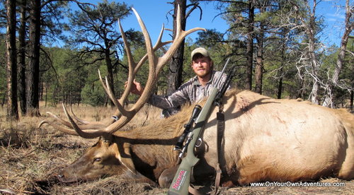
Also, if you hunt arid states like NM and AZ, these chips show you the waterholes. Many of the waterholes they show are not marked on Forest Service maps. If you find one not marked in the USFS map, like we did, you might even shoot a bull like this as he comes to water.

IMG_0225.JPG
 
I've been using some free software and have had it work pretty well for me when looking at ownership but I'm not sure it's as accurate.

I'm interested in seeing a side-by-side comparison between the HuntingGPSMaps and the free stuff. Anybody ever do that yet?
 
This is a great tool, I use them for big game and upland game hunting. Most definitely one of the best investments you can make. I have the download version that I can use with basecamp. I also have the google earth version. This allows me to use and move points between both basecamp and google earth. You'll need a conversion program though to use the points between the two pieces of software.
 
Last edited:
I've been using some free software and have had it work pretty well for me when looking at ownership but I'm not sure it's as accurate.

I'm interested in seeing a side-by-side comparison between the HuntingGPSMaps and the free stuff. Anybody ever do that yet?

Go find some survey markers. In my tests, accuaracy was not good enough to build a house, but plenty for hunting and work.:D
 
A great tool! Areas I hunt have private mixed here and there... nothing beats knowing where I am in relation to private land. Ability to pack out through areas I've not traveled before with reasonable understanding that I'm not crossing private land, etc.

Fantastic tool!

I use the download versus the chip... It allows me to work in conjunction with Garmin's "base camp" on my computers as well. The chips only work with the gps (unless something has changed since...?)
 
I've been using some free software and have had it work pretty well for me when looking at ownership but I'm not sure it's as accurate.

I'm interested in seeing a side-by-side comparison between the HuntingGPSMaps and the free stuff. Anybody ever do that yet?

The data is all the same. Spatially it may be represented a little differently, but the base data itself is the same and comes from all the same sources. I will save my hundred bucks every year and continue to use the free version online. For 20 minutes worth of work it's a steal.
 
I just checked out the videos and I think I saw Miller's property. Those look pretty cool. I'll definitely have to check them out. They have free android apps for a lot of the western states too.
 
It's been invaluable for many of my hunts as well. I use some of the 'free' sites and use ArcMap at work to do some cool aerial photos, but it's the best thing I've found to have in my pocket in the field.

-Cade
www.HuntForeverWest.com
 
My buddy bought one of the chips this year for CO, they're really slick. I just wish they had a Delorme compatible version... :(
 
Only problem I have with it is in HICK north Idaho some of the counties are not up with the computer age and the landowners are not listed. However it was invaluable in Wyoming this year for antelope hunting. I just with north Idaho would get with the program.
 
I'm one happy customer for sure. They are pretty amazing! This last season my father-in-law bought a competing brand and for the same price my maps actually had more information and detail. Pretty awesome stuff.
 
Leupold BX-4 Rangefinding Binoculars

Latest posts

Forum statistics

Threads
111,399
Messages
1,957,456
Members
35,161
Latest member
mrturtle
Back
Top