Understanding road access on topo maps

Ohboytimmy

New member
Joined
Jul 27, 2016
Messages
64
Location
Minneapolis
5249175408345088.jpg

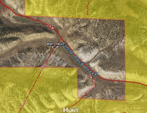
This maybe a simple question for most of you but I am still a greenhorn to western hunting. I have been doing my homework for this fall's elk hunt in a new area. I am wondering about road access driving through private land.

If you are able to see the picture, probably obvious CoR20 is open to the public. Am I able to drive south on BLM1027 through Oscar Wyatt and head back into BLM territory?

Further on Co Road 20 there is a road labeled as "private road." I am assuming that's a road established by Oscar Wyatt that I am not able to use.

Just want to verify that anything listed as "state forest road, BLM rd, or any state/federal owned" is free for me to roam?

Is there anything I should be aware of before I commit a route through public and federal land.

Sorry for such an amateur question. I may just be over thinking about this.
 
Last edited:
Look at the travel management plan for the blm in this case. Also call the local blm office and verify whether or not there is an easement. In mt a lot of roads like that will NOT have public access.
 
Sure wish that was easy to answer, but apparently in some states even state maintained , BLM, or federal roads can sometimes be restricted or closed to the public at the request of adjacent land owners or agricultural lease holders .
Good plan is to identify possible access on map and clear it with local warden. Be sure to write down name of warden, his cell number, and date you spoke for future reference.
But, in general you are correct, just not 100% in all cases. Ranchers and farmers can and do have alot of say in certain situations as to traffic on those roads.
Wish I had better information for you but it is what it is sometimes.
 
Public roads can not be closed by private citizens, unfortunately there are some land owners that will post that public roads as closed and unless you want to confront them it's usually advisable to not cross those kinds of roads. Check with the local federal authorities to verify if the roads are open. Personally if it's a public road I don't give a flip what some land owner says but then I've always been a contrary kind of person.
 
Assuming that road has a public easement across the private because it's labeled CR20 can get you in trouble.
Go to the County for county roads, BLM for blm roads.
 
Sometimes you need more than one map. I can pick up a map that shows me a FS road exists but it doesn't show me if its closed. But it shows topography so I need it. I need a FS map to show road closure dates and open and closed roads. But the FS ones I have don't have topo. So I need both maps.
 
Assuming that road has a public easement across the private because it's labeled CR20 can get you in trouble.
Go to the County for county roads, BLM for blm roads.

Go to the source for answers, seems like what I need to do. Thanks for the advice everybody. This elk hunting stuff is work work work
 
MTNTOUGH - Use promo code RANDY for 30 days free

Latest posts

Forum statistics

Threads
111,311
Messages
1,954,324
Members
35,118
Latest member
Loper96
Back
Top