Wilks brothers true colors are shining through.....

The kind/amount/class of livestock that is permitted for those lands is on the permit, which can be gotten online. FWIW...

I just checked and both of the allotments (NBar and Pronghorn Ranch) with the Wilks Ranch Montana, LTD listed as the permittee are only permitted for cattle.
 
He then stated this was just some hunters that are mad and was worried this is going to get out of control, expressed that he wanted to get the Farm Bureau involved.

Uh, yea, it seems getting the BLM and politicians out of control of the Wilks is a splendid idea. What does he think will happen? What does he hope to accomplish by bringing the Farm Bureau in?
 
I'm confused.

Wilkes called you?

Or someone running cattle on Wilkes property who put up the fence for his own critters?

Or it was roadhunter posing as a rancher?
 
Maybe 1_p has a better source, but I look up BLM permits on Geocommunicator.

http://www.geocommunicator.gov/GeoComm/

Click on "interactive maps", select "rangeland" in the layers menu on the right, zoom to the allotment and use the "identify" tool and click on the allotment, then choose the "rangeland" tab on the popup.

That's the one I'm familiar with.
 
Oak, thanks for the link and directions. I bloody love databases, so this fencing issue aside, I know I will be digging into this programs on other matters.

Belly, I dont know the name of the guy that called me, he did not identify himself and when I asked at one point, whether he heard me or not I cant say, but he continued on with his opinion of various things like the bison killing people and wolves. He asked about EMWH, possibly signing up for the newsletter and thanked me for the conversation. He was very polite, though we clearly did not agree on some perspectives.

The phone number he called from was one with an area code for southern Kansas with Southwestern Bell, but that might not have been his phone, seeing how he said he moved from Minnesota and had a place here in Montana. Anyone familiar with my research might be concerned about using a number I could trace to certain areas and use a borrowed phone. I dont want to divulge any of the personal information or phone number as I dont think, at this time, that it is pertinent to the conversation at hand.

This guy did not address himself as being a Wilks employee, but as having received permission from them to drive the trailer through there. That is all he discussed on that front.

I think the Farm Bureau was brought into the subject simply because the Farm Bureau is an established organization with a network, powerbase, money and presence. That doesnt mean they can do anything about these particular laws, but there is the potential that they might try to muscle the situation, especially if they are worried about a bunch of public hunters armed with fencing laws trying to fight for the public lands.
 
I went to the FWP Commission meeting today to hear the elk presentation they were holding to deal with some of the issues on elk season structure review. The were also some votes on bighorn sheep out of state transplants the quarantine bison placement I wanted to comment on. I could not stay for the Wanken settlement portion later in the day.

During the Commissioner region reports they brought up the Durfee Hills fencing situation. It began with Region 5's Comm. Tourtlotte who opened the discussion of the Durfee Hills by stating that the BLM was up there doing the survey. I dont know if he meant that they were committed to doing one or if they were up there right now doing one. Then stating he had received a number of calls, spoke to the outrage of the public, but said, "...other things that not sure anything came of this but there were accusations that blocking of the, theres a landing strip on there that ended up being a none issue." He spoke concerning the fence that some thought it was going to be a 8 ft high fence but that it looked like a standard fence from the photographs.

Then Comm. Stuker mentioned it, stating he had attended a Region 4 CAC meeting in Oct, where access was discussed and the Durfee Hills brought up. Someone at the meeting said they were going to find that the fences were 53-54" high, would obstruct wildlife, said it shouldnt affect adults but depending on the bottom wire might obstruct the calves. He mentioned that that would be similar to his which are 48-50" high.

Then Comm. Vermillion said that he had also received a number of calls on the Durfee Hills issue, access brought up and mentioned that changing ownership is affecting the access issue, needs more dialogue.

At the lunch break, I spoke briefly with Matt Tourtlotte on this issue, stating that some of the statements expressed were based on misinformation, probably based on the BLM press release which has been redacted. I told him of the laws, the current BLM statement, the survey that will be done, but even if the fence is entirely on private land, that does not address the structure of the fence and the Unlawful Inclosures of Public Lands Act, Montana Legal Fencing and the BLM fencing regs. That if there is encroachment, you have a caterpillar that did not have a permit ripping up public lands, trees downed and piled up, as well as regs for a camper parked in the road, unattended, blocking public hunter access, etc. I mentioned to him that there was a state parcel connected to the Durfees that needs to be addressed. I could only cover a small amount of this issue in a few minutes.

He gave me his card to send info, so I decided to send it to all the commissioners, but thought to post to y'all that some of you might want to get in touch with your commissioners, if you feel so inclined, to get them up to speed on what is really going on over there - stop the misinformation that is floating around like the earlier press release. There is state land involved as well which is being looked into.

Here are the email addresses if you dont have them:
District 1 Gary Wolfe [email protected]
District 2 Dan Vermillion [email protected]
District 3 Richard Stuker [email protected]
District 4 Larry Wetsit [email protected]
District 5 Matt Tourtlotte [email protected]
 
Kat, did the Billings Gazette ever correct their article?

I had not seen anything on my feed and just checked, just the Oct. 1st press release one. He may be waiting to see the results of the survey before writing another.

I was just getting all my stuff (tape measure and camera for sure) loaded to go out this weekend and document areas. I heard there was an illegal trail on the State land, trying to see if it would show on the aerial view up close. Then got caught up trying to match up where that trailer was. I want to measure the distance it was on the dry road from the rutted road. Visually it does not look like it was parked 300 feet off, but harder to tell with pictures sometimes. I was using the width of the trailer to gauge distance. If the standard travel trail is 8 feet (96 inches) wide, visually there is no way that trailer can be 300 feet off the road to park. I printed out Wingmans pic to locate and measure.
 
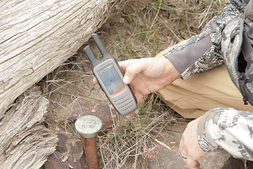
Corner Pin for State/BLM/Wilks boundary. GPS showed my location as being 15 feet away. So pretty darn close and within the GPS accuracy of 10-20 feet.
 

Attachments

  • Corner PIn.jpg
    Corner PIn.jpg
    306.1 KB · Views: 1,208
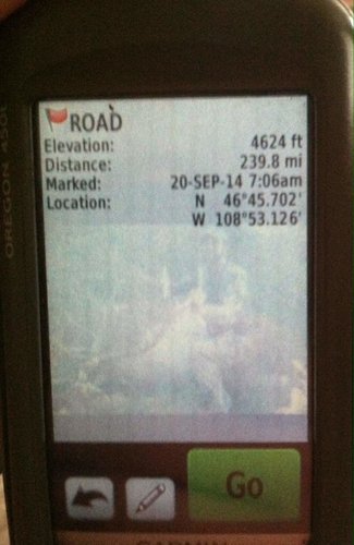
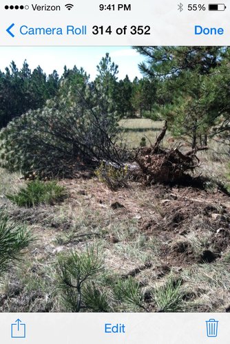
Hey Kat. Here is the pic of the tree that CAT plowed over and the coordinates of the road he was "trying" to drive on. From that location start walking north and you will see the other trees he also drove over. As you walking to the boundary on that you will find multiple places he drove off road.
 

Attachments

  • image.jpg
    image.jpg
    95.1 KB · Views: 1,138
Hank, thank you for the pics.

I got in to Lewistown shortly before the DNRC closed. I wanted to get some maps and information on the State section 36 adjoining the Durfees. The topo, aerial and ownership maps I printed out from Cadastral were better than what they had in their file, but what I couldnt find was a map of the trails and roads ( I had several people tell me there is an illegal road on there). The woman helping in the office said I would have to check with Clive on Monday. I did find out there is a cattle grazing lease, but I will also have to check on terms and conditions Monday. When I asked about the DNRC fencing she said it was Montana legal fencing which is 15-18" bottom wire from the ground and max height 44-48".

The camper guy called again and left a message on my phone while I was driving here (he did not leave a name). He does not like the whole conversation not being quoted. He said he was upset that when he spoke about the sheep that I did not bring up the leafy spurge, sheep being used to treat leafy spurge. When I get home I will transcribe the whole call so that he is quoted fully about how he feels people are acting juvenile about this fence situation, is disappointed in me and is confusing this forum with my website/blog and newsletter.

I brought the Realty Trespass Abatement book with me, hoping to have time to begin reading it (this is bloody awesome). In the introduction it states,
"Realty trespass prevention requires a public that is knowledgeable of the public lands and resources and conditions for authorized use of the public lands...Public awareness and support is essential to successful trespass prevention...Detection may also involve report by the public, data of other agencies, and inventory or survey to identify or confirm suspected trespass."
 
Last edited:
If the sheep are being used to treat weeds on the BLM side there has to be a paper trail. LIvestock can not be temporarily permitted or used for vegetation control without at least a Categorical Exclustion. Heck, depending on the grazing permits for the units, they may not be able to use them on private lands without BLM concurrence and paperwork.
 
1_Pointer, I dont know that sheep are currently or recently with the Wilks have been on there. Camper guy just brought it up in relation to a 5 wire fence and others have stated sheep used to be on there. We need to find out the grazing permits, the terms and conditions, which are public information according to the Code of Federal Regulations I was just reading through.

Reading through this Trespass manual, I have been downloading the forms in the trespass reporting and investigation process that BLM is required to go through. According to this, "...the case begins with discovery and recordation of suspected unauthorized use, occupancy, or development of the public lands." So at the very least, when I contacted Billings BLM about my concerns and the laws, A Form 9230-10 should have been filled out, or possibly when I sent the email in with the same information. Technically, one should have been done when others also called in earlier.

Another statement says, "For the purpose of reporting incidents of trespass, employees shall record all occupancy, use, and development as if it is unauthorized, pending a determination that the use, occupancy, or development has been authorized by the Bureau." "In those instances where law enforcement action is required for the prevention or abatement of an unauthorized use or development, such action will be aggressively pursued by the Bureau." Glad to hear that.

They have a whle list of the types of documentation required in the investigation, including photos, maps, sketches, field notes and measurements.
 
There is nothing on the permits about sheep. You stated the caller stated the fence may be for sheep and someone then mentioned they might be used for weed control. I was just pointing out, that if sheep were used for weed control on the BLM there would have to be a paper trail. However, sheep could be authorized on an Exchanage of Use Agreement. That information is not on geocommunicator.
 
Just got back from the Durfees, awesome flight. I will get the videos and pics uploaded and noted on a map when I get back to Bozeman Tuesday. There were two other hunters from Bozeman that we met as we were leaving (showing there are hunters from a number of locations enjoying this section of State and Federal public land). I didnt get to document as much as I would have liked, but was grateful for the time I did have, may go back in a few days for a three day trip. But part of this trip involved one of the guys getting a bull (7x6), hiking over to that area, which was on the State parcel western side. That is what all this awareness is for. I also documented the atv trail on the State section

I did verify the piles, disturbed ground and vegetative destruction on the State parcel, the fence height there (northside), which was not completed before all this became public is averaging about 47 inches, but the bottom of the five wires is lower than Montana legal fencing. The fence height was higher on the BLM section we checked on later (also had piles, lots of Cat tracks that Hank showed and mentioned). There was some fencing construction trash in a number of places.
 
I just got out of the DNRC office, spoke with Clive Rooney. I gave him a copy of my pics and videos of the fencing on the north side of the DNRC section 36 and the western fence. I asked to see the grazing lease with terms and conditions. Point 8, Improvements states the lessee has to have approval by the Department before they can make such improvements. The Wilks did not make any proposals for fencing on the west or north side.

They are aware of this process because in 2012 they made a proposal to run fencing from east to west, about 600'-800' from the southern boundary. DNRC denied this proposal citing the fence would traverse through the middle of three DNRC Harvest Units. So the Wilks clearly know the process for fencing proposals. Now, they could possibly say that they needed no permission as the fence was being constructed on their land, not DNRC, but there is no professional survey on this DNRC parcel either, so until a survey is conducted for this DNRC parcel, we wont know if the Wilks violated the terms of their DNRC grazing lease.

To proceed further, I have to submit an official complaint letter to their office which I am doing tomorrow. I have already given my photo and video documentation to DNRC. As soon as I get back, I will scan these documents and post them.
 
Back
Top