On the Subject of Land Exchanges

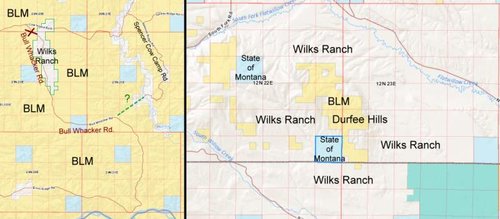
To boil it down to the most simple terms, we have two ways to access the 50,000 acres of BLM ground.

1. Do we want to spend $300K-$600K for that access, or

2. Do we want to trade 2,700 acres?

Or... 3. Convince the BLM to pioneer a two-track road around the property?

I've already offered my services for free. The road could always be improved in the future, but in the meantime, why not drive around it so Wilkes can't hold the BLM hostage for the access.
 
Or... 3. Convince the BLM to pioneer a two-track road around the property?

I've already offered my services for free. The road could always be improved in the future, but in the meantime, why not drive around it so Wilkes can't hold the BLM hostage for the access.

Agreed. I was told to pioneer a two track it would take $300K. For a real road, $600K.
 
I was told yesterday by someone that does business up there in the Breaks, that rumor was, the Wilks were trying to buy the private property in the lower left corner of the first map. Ervin Ridge Rd. runs right through it, then connects to the southern portion of the Bull Whacker. The Pinwheel J Ranch LLC has a Loomis, CA address for ownership on Cadastral. The same Pinwheel J Ranch owns a number of the parcels, further to the west, where Ervin Ridge Rd begins, off of LLoyd Rd., then enters onto BLM land. If Wilks were trying to buy that, they could essentially cut that whole route off.
 
Think outside to box people. The Wilks have other land holdings outside the Breaks, and even other land not mentioned in the article. So who is to say a land swap will involve the Breaks, or an access road and land and when? Where are the rumors comming from?
 
I have no problem with wealthy individuals deciding to become "ranchers" ,but when they use their wealth and influence to close public roads and deny legal access to public lands...well thats where I draw the line.
 
So who is to say a land swap will involve the Breaks, or an access road and land and when?

Since the Anchor Ranch in the Breaks is what has been proposed by the group wanting the exchange, I think that answers the "who is" question. It is the owners of said ranches who have approached the BLM to consider an exchange, not the BLM approaching the ranch owners

I think the official proposal from the Wilkes Brothers will be soon forthcoming. Hopefully that will give us certainty of what has been proposed.

Where are the rumors coming from?

The emails I have are coming from BLM people authorized to lead the BLM on such discussions. I suspect that is where the information is coming from.

To note, the BLM has stated they do not want to go another hunting season without access to the 53,000 acres in the Bullwhacker area that is no longer accessible through the Anchor Ranch. The BLM has stated that if the exchange is not supported, they want to find other alternatives to access the Bullwhacker parcels.

Point being, we can get much better deal than what the has been tentatively proposed. Maybe the official proposal will be more appealing.

Given the BLM is interested in keeping access at, or above current levels, and there are many people/groups talking about this, publicly and privately, we might be able to keep all parcels and have access to all of them.
 
Any idea of a time frame of how long it takes to have a BLM land exchange...a few months...a few years. How long does it take?
 
Last edited:
$300K - $600K seems awful high to me? I've been involved in a lot of road building and for that price it should be a high standard well graveled road. Unless they are factoring in the agency personnel time to complete the environmental documents?
 
Any idea of a time frame of how long it takes to have a BLM land exchange...a few months...a few years. How long does it take?
All of the above! In my limited experience with land swaps, the biggest time variable is in Washington DC and correct appraisals second. IIRC all land swaps require congressional approval. So, alot depends on how bad those in DC want to make it happen. I know of one that went through in a couple of years and that was considered fast by the folks working on it. That landowner was well connected with elected officials so I'm thinking that helped expedite the process as well as it including parcels in a newly designated wilderness area.
 
Attached map graphic showing both parcels in discussion

The Bullwhacker area is shown on the left map with a dashed green line and question mark to indicate the general vicinity of an access route coming in from the east. The right hand map is the Little Snowies area of the Wilks' consolidated holding in southern Fergus County. It shows the location of the Durfee Hills parcel within the Wilks Ranch. A number of questions have been asked on this thread about how and why the Bullwhacker Road came to be closed. If there is enough interest and can write a history of events over the past 10 or 12 years. .... Ron ....
 

Attachments

  • BLM trade.jpg
    BLM trade.jpg
    37.4 KB · Views: 115

Forum statistics

Threads
111,267
Messages
1,952,931
Members
35,104
Latest member
Fallguy
Back
Top