Blm easments maps?for wyoming

dan.kirkpatrick

Well-known member
Joined
Jul 9, 2010
Messages
2,317
Location
mulino oregon
I was wondering if anybody out there has found a way to find out about "easements" thru land to get to blm public grounds?I know county maps are 1 way,,but none that i know of show public easements thru that we as public hunters would like to know?Is the blm numbered roads the only ones with easements?It would be magical if someone could come out with a map that truly shows this for wyoming.
 
I use my blm maps,gps chip for the state,county map,gazzetter atlas ect,let alone the tan markings,but there are some that have to be presumed private ,even if theres no sign once you are on the ground there,,I like verification to make sure it legit.
 
I'm interested as well. I was driving a county road last fall and all of a sudden it had a homemade gate closing it off with a bunch of signs saying no trespassing. None of my maps showed this road as a private road. Frustrating!
 
This reminds me, I encountered a gate on a County road to access a sweet section of BLM this fall, I initially reported it to the BLM and County, but need to follow up.

The realestate specialist for the BLM jurisdiction 'should' know where these easements you mention are, that may be a good call to make first. You should be able to call the local office and ask for the real estate person to get in touch with them.
 
on the blm maps themselves ,the roads that are numbred with a square around them are public county roads,there are some numbered looking roads that i think are public blm but it is definately hard to know for sure if you run into somebody posting there own signs to argue with if there is a confrontation over trespass?as a non- res im sure they will point the finger ya know.It is frustrating when you try to do everything you can to be honest and correct.
 
Go to geocommunicator's website. They have the contact info for all of the GIS and/or Realty folks who should have this data. I looked briefly and didn't see any data listed on the site for travel easements. However, I'm betting a few emails and/or phone call can net you the info you are looking for. Be forewarned though, that much of this info is older and not all of it is digitized.
 
I have a huntinggpsmaps card. I run into "private roads" all the time...so much fun.

It must be nice to have a "private road" with a ton of public land at the end. I would just call BLM and start asking questions...couldn't hurt anything.
 
I think just contacting the agency who manages the parcel is always the way to go. Another thing you can do to find "right of ways" is look at old Certificates of Survey. Right of Ways and easements come and go, but it can be helpful.

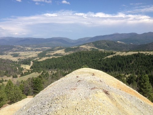
For example: Recently near where I live, a right of way existed to a parcel of BLM. This right of way went through a couple hundred acres of private land and was in use by the public for at least the last fifty years You could clearly see the right of way recorded on the original C.O.S. that was performed on this chunk of acreage. Recently, this land was subdivided into 40 acre parcels, and the owners of these parcels, now block access to that chunk of BLM(400+ acres). In reviewing the C.O.S. that created the subdivision, the Right of Way is now gone as is any public access to this chunk of country. Which is good elk and deer country.


That's as far as I've taken my research with this land. But this summer, when the hills are accessible, I plan on raising hell with the office in Butte. Here's a pic taken from a mine tailings pile of that chunk of country from a couple years ago.
 

Attachments

  • Alta.JPG
    Alta.JPG
    148.5 KB · Views: 318
This sign post by land owners is a big thorn in my side for over 35 years. They used to scare people off of public land with them but people are getting smarter with knowledge and GPS. They also tear up or deface the road signs to trip us up too. You cannot be kept off any public road-federal,state,county,blm,forest service period. They might own the land but the road is ours. Right of way and easements have needed to be made clear for 50 years or more, and the land owner has to go to court to show a just cause to close one. Some have did this here and got it closed or closed for winter because of destruction of the roads, or so their paying hunters can be the only ones to use it.
Oh they may put a gate across it to "keep livestock in" and post signs on both sides, but that is cheap insurance to keep us out. Putting a lock on that gate is now a fineable offense. I have had them do this and I would have a BLM Map in my hand telling me it was public road. More than one has ended with a sheriff coming out and you can swear a complaint against the landowner and make them show up in court, most won't. I will say again and again the Wyoming Game and Fish will issue me a trespass citation and maybe haul my butt off, but they will NEVER issue anything to a land owner for any reason other than maybe poaching.
 
Last edited:
Oh they may put a gate across it to "keep livestock in" and post signs on both sides, but that is cheap insurance to keep us out. Putting a lock on that gate is now a fineable offense. I have had them do this and I would have a BLM Map in my hand telling me it was public road. More than one has ended with a sheriff coming out and you can swear a complaint against the landowner and make them show up in court, most won't. I will say again and again the Wyoming Game and Fish will issue me a trespass citation and maybe haul my butt off, but they will NEVER issue anything to a land owner for any reason other than maybe poaching.
Every thought that may be due to the fact, that for the most part, G&F doesn't have jurisdiction over posting/closing federal lands? I bet you'd get different action from a BLM/USFS LEO, but wether or not the local judge will up hold the ticket is an entirely different matter.
 
Ollin Magnetic Digiscoping Systems

Forum statistics

Threads
111,183
Messages
1,950,261
Members
35,069
Latest member
Mtbirdandbiggamehunter
Back
Top