Leupold BX-4 Rangefinding Binoculars

Google Scouting Tips Wanted.

Jchiggins2012

Member
Joined
Feb 25, 2018
Messages
51
Location
Salt Lake City
Just watching FT S5 E6 and Randy mentions using google earth to find good elk retreats up in the cliffs in CO. Just wondering if any of you do this? If so.... What exactly am I looking for? Im a newbie in all regards to hunting and scouting locations.

Thanks,
J

K ** Shoulda Googled that **** **, just found a couple good videos on top of Randys E Scouting video on you.
 
I use ge pro for 99% of my scouting. First thing I do is mark all the roads. I don't look for bedding areas, transition area, feed areas, dark timber, or north slopes.

Roads, and lack thereof.
 
I use ge pro for 99% of my scouting. First thing I do is mark all the roads. I don't look for bedding areas, transition area, feed areas, dark timber, or north slopes.

Roads, and lack thereof.

I second this—I’m looking for roads. Nothing is as disheartening as hiking for a couple of hours and hearing the distinctive whine from an atv in the area you are headed. If you can find some promising country with little road access, start there (using Randy’s video series as a guide).
 
the areas I look for work better for sept archery. But i've had good success finding wallows, trails, and even some elk (you need really high res for that). But generally I just look for good feeding areas (wet/green), and try to use the closest aerial to the date I'll be hunting.
 
I look for areas away from roads or trails that are steep and where I think no one will go. Sometimes they are not that far its just where other people don't want to hike into. In my own personal experience I feel that most people in the area I hunt wont walk more than a mile in. Good luck to you!
 
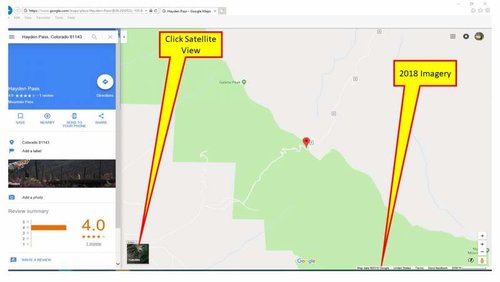
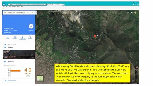
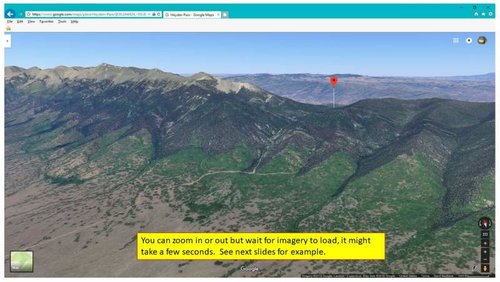
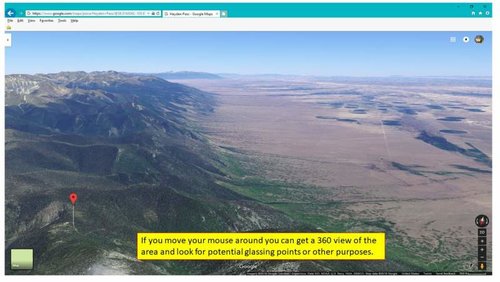
Let's share this little secret so you can e-Scout better from your own computer using Google Maps.

Find you area via Google Maps. See next pictures for Example and info. – ColoradoHunter719
Slide1.jpg

Slide2.jpg

Slide3.jpg

Slide4.jpg
 
Has anyone used the "Show Viewshed" option? It comes up when you right click on a placemark. It hasn't worked for me in a few months so I'm curious on whether it is on my end or something else.
 
FYI the imagery date in google maps is not the actual date the imagery was taken. It's basically the license date, which is almost always now. I mean 2018 imagery... without snow? GE is still far superior to scout with. I have a pile of kmz loaded that can be toggled on and off included old USGS maps, previously identified features (wallows, trails, glassing spots), parcels (though not current, just a snapshot in time), plus like I said previously you can using go back through the older aerials and find one that close or even during your hunting season and mark other camps, so you know where others might be or where you could camp.
 
onXmaps has a good layer for finding roadless areas now. But as far as google earth. I scour the hills for what looks like interesting features and pin them with a short name ill understand looking at a GPS. I export it to basecamp and then import into my Garmin. I still do not trust my phone. When they seem to break after a year of use, I do not plan to make it my main GPS. Even with airplane mode and every other data and battery sucking feature off I can maybe get a day at the most out of it where my 9 year old GPS still gets at least 2.5 days when left on the entire time and I have a second battery pack I can toss AA batteries in and use it still. I use past imagery dates when I find a water source I want to check out because you can get an idea on whether water is hit or miss or year round. Imagine hiking 2k feet in elevation up a hill to what looks like a killer water hole only to find it cracked and dry in September. Had I known it drys up like the past imagery would have shown my id have been less bummed when I found it like I did.

Back when I used to blog I tried to make a detailed outline of what I do. Obviously some of it has or can be improved on. Some info even used from WapitiBob (I think). But if you wish to read it here is a link. I have not updated the story in about 3 years I think as the writing bug left for a while. But might be a decent starting point at least to see what features look like in google earth compared to to actual landscape.

https://starvingoutdoorsman.wordpress.com/2013/08/13/scouting-from-your-desk-with-google-earth/
 
Not trying to hijack thread but one thing that seems very helpful is the measuring tools. I try to judge shot distance with them. Anyone know how accurate the distance tool is? The straight line and ground measurements don't seem to agree when measuring across canyon.

I do want to add that trails are easy to see on open slopes. I have confirmed some good areas with this. Just make sure there aren't cows in the area :)
 
Last edited:
Great info and resources listed above. One thing I might add, look for barriers that would prevent or discourage others from going into the area. This can be boulder fields, rock slides, ultra steep side hills, cliffs, heavy blow down areas, and primitive boundaries (keeps the cattle/sheep out). Too many times I thought I had found a great area only to scout and find horse camps, sheep, cattle or a large number of hunters in the area. It seems if I can find an area that a horse can not get into because of barriers there are good odds the elk are in the area.
 
I've got a good system going for E-scouting for MT mule deer using ONX and GE together
First thing i did was took a look at ONX and dropped pins on public land that is:
A.) Close to home, and further from home depending on how much time i have for a hunt.
B.) Actually accesible
C.) Looks like decent habitat for Mule deer
I just labeled them all "MULEYS"

My next step was to export those pins over to Google Earth so that i could see my points of interest on GE
Next i searched for a MT public land KMZ file, cant remember off hand where i found it but a little searching on google should pop something up. There are also many different KMZ or KML files out there for all sorts of different things that may be useful, such as topo, burns, migration routes and such.

So after downloading that i had my pins dropped on google earth and could see the boundaries of the public land i was looking at on GE, so basically im looking at ONX on GE if that makes sense.

From there you will have to do some work on changing the transparency of the public land polygons so you can actually see the landscape, which of course is totally customizable depending on what colors you want to use for what.

Now I've been tackling each piece one by one and marking water, potential food sources, bedding areas, glassing points, north facing slopes with cover, and also marking down access points and roads so i can visually see what spots within the public land are good spots to start scouting. I've actually eliminated a few points of interest just because it may not look like what i thought it was going to from ONX to GE, so its probably saved me a lot of time and gas that way.

Hope this helps!
If you want to see some actual examples let me know i can definitely share!
 
Last edited:
All good tips!! Key is spending long hours on google earth learning every inch and doing your best without actually putting boots on the ground!
 
I have a question, when using OnX, or even GoogleEarth, what 'zoom level' do you find most helpful to establish an initial area? I feel that is something I struggle with. As if maybe I'm too far zoomed out and focusing on areas way bigger than I can actually hunt, and therefore make me feel like there are roads and trails everywhere. Lately I've been trying to view the OnX maps where the scale/legend in the corner of the screen is representing either 2000 ft or 5000 ft. Once you have an area defined, I can see zooming in as far as possible to define certain properties, but I'm just referring to when scanning units for roads/trails/etc.
 

Latest posts

Forum statistics

Threads
111,118
Messages
1,947,711
Members
35,033
Latest member
Leejones
Back
Top