Arizona Unit 7 East Peaks

TexRed

Member
Joined
Mar 26, 2017
Messages
35
Location
Texas
My cousin and I drew this tag for Mid Oct rifle season. It will be both of our first elk hunts and I realize it will be a challenge. Ive been working my a$$ off to get in shape both mentally and physically.

Anyone out there that would be willing to shed a little light on what we are in for? Maybe some tips and suggestions on where to start?
 
Am I correct that your hunt is an antler less hunt? Water is always a good bet, since by mid October the monsoon rains will be over and the forage will be drying out by then. I'd work up high on the mountain on all sides, but especially the big burn on the east side of the mountain. Most of the area will be in the Kachina Peaks wilderness area. I'd get up above the 9500 ft level or higher since its the easiest area for elk to get to when pressured. Another area would be some older burns on the north side of the mountain. A lot will depend on the weather, early snow can push them down to the north out to the CO Bar ranch (goes up to and across the unit 9 boundary). There is no problem with access there. The Babbitt family does not charge trespass fees or any other charges. Wish others were as descent. Get there early so you familiarize yourself with the area. I'd get a "Flatline" map for the unit. It will really help with roads, trails and water. GJ
 
Last edited:
I really appriciate the response! This is more information than I have gained total so far and I've been 'researching' since I found out I drew.

Its actually a Bull tag! Its the second rifle season I believe.
How much land does the Babbitt family own? I was under the impression that the unit was around 90%+ public land.
Is there any issues with camping throughout the unit or can you set up camp wherever you please? I also saw that there were some signs on google earth images about not leaving trails due to native tundra, does this apply during hunting season or just for general hiking?

How scare is water? I ask because I don't want to have to rely on carrying all our water in on our backs. Will we be able to find springs/creeks/tanks or even wallows to purify for cooking and drinking?
 
When is your season?. I can't seem to locate a bull season in the October time frame you mentioned. That will change a few things, but not much. I hate to disappoint you but there are no creeks and only a few springs. The Merriam's base camp does have a good spring. These Mountains were called by the Spanish, "Sierra sine agua", which means mountains without water. The rock is very porous and the precip sinks in until it hits a non porous layer and comes out 2000 ft lower (oak creek, beaver creek, west clear, etc.). There are dirt tanks and there are a series of cattle drinkers near SP crater on the CO Bar. The land is mostly public, Babbitt's leases alternate sectiones of state land in that area. I believe the various sections of the CO Bar cover about 250,000 acres in No. AZ. You can camp pretty much anywhere. I've drank from a lot of grim puddles over the years, but never from a wallow. You guys are tougher than me. I lived in Flag for almost 40 years and always brought my own water. If you had a White Men. hunt in eastern AZ there are lots of streams and good trout fishing, but its a different type of rock over there. Found your hunt, its one of the limited opportunity hunts. Its looks to be confined to the the wilderness area mostly. Get a "Flatline map" and mark out the boundaries to make sure. The area east of hwy 180 is not in the wilderness and has vehicle access. Now that I know where your hunt is you might want to get some "rocky mtn elk calls", they sound better and you may still be able to use them for a few satellite bulls still looking for cows. The big boys have probably gone high, looking for sanctuary areas until the weather forces them down. This doesn't mean you won't find one close to a road of course. Sorry for this rambling post, but I thought you had a cow tag for the first part of it. Now its just FYI. GJ
 
Last edited:
Correct. We are confined to the peaks and small surrounding area. When you say the big bulls have gone high... how high are you talking? Above treeline?

Right now I am considering getting up in the mountains and finding a high spot and glassing early morning and late evening for bulls to step out of their sanctuaries. Is there a decent number of clearings to glass? Do they tend to prefer a certain side of the mountain when seeking sanctuary?

Do the springs run year round? Are there some that are more productive/reliable than others? I have marked a bunch of springs and tanks that are listed on the maps.
 
The Merriam spring is always good, also leroux spring, which is in the hotshot camp. If there is a good monsoon the other springs will be flowing. The tanks will be pretty full. These are dirt tanks and muddy. There is a good tank on the top of Shultz peak. This area was burned so there will be new growth by now. There are high points above meadows on the south and west sides. Abineau canyon has a steep avalanche chute that can be reached by trail. I'd contact the NFS office and AzGFD office in Flag can give a better report on spring flow. These are often just seep springs so I won't count on too much. The Peaks are steep sided and you will be able to glass openings. There is some private land on the west side than is posted. The Nature Conservancy has a 250 acre on the west side on Hart Prairie that has springs and water. Ask game and fish if it is open to hunting. The people who owned it previously had it closed. If the weather is decent you will be up over 10,000 ft if the weather has been rainy/sleety up high they will move down (just like elk do). There is plenty of water for wildlife but bring lots of filters for tank water. Years ago, a local pharmacist made me a pint bottle of water with some metallic Iodine. I put one capfull in a pint of water waited a half hour and was good to go. If you want to fool around with this stuff, don't swallow any metallic Iodine. Its hard to give you definitive answers till after summer monsoons. There is a lot of snow up there now (over 80 inches) so spring will be good with good antler growth. The Hochderffer hills are on the north west side of your area and has a large burn. You can glass them from Hwy 180, Kendrick park area looking south.. They are steep with lots of blowdowns but would be a good sanctuary area too. Lots of ideas for you here. GJ
 
Last edited:
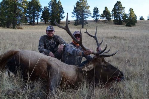
We busted our tails and ended up harvesting a respectable 6x6. I will try to figure out how to post some pictures.

We started out in the wilderness area. It was quite a trek to get where we ended up camping for 3 nights. Since we aren't locals with caches everywhere we had to pack our water up with us. We focused on the area where the forest met the burn. Saw lots of elk sign and spotted multiple elk (cows and bulls) in the distance on other mountains. Saw lots of other hunters that had similar idea as us. Had an bull bugling on the second morning but couldn't lay eyes on him and swirling winds ended up getting the better of us. We found fresh elk sign and multiple kills the first few days but never saw an elk within rifle range.
On the early morning of day 4 we were packing camp to still hunt down. I decided to check a clearing while my cousin was finishing gathering his stuff. I arrived at the clearing and heard a crash in some brush down the hill. I had spooked 3 small bulls, within 100 yards, and the were side hilling right in front of me. I raised my rifle, settled the crosshairs on one and fired.
When all this happened it was a few minutes after legal shooting light. They elk vanished over the crown of the mountain and spilled off into the trees. My cousin comes running up. I explain what happened and we start looking for blood and tracking. We never found blood or the elk. We determined that with my rifle being zero'd at 250 yards and shooting downhill I had shot over him with a clean miss. Lesson learned.
We spent the rest of the morning still hunting down the mountain and rehydrating.

Evening of day 4 we sat over some water and an open meadow on the north side of the unit. No luck. The morning of day 5 we tried the same tactic. No luck. Not even any fresh sign. The elk had all moved to the deep dark timber and were moving at night.

We decided to move to plan B that I had already marked on my maps from online scouting. We moved toward the western part of the unit and started hiking up a small mountain. We got to the top and were admiring the scenery, taking pictures and talking about how we should come back during ski season. I turned around and saw 4 cow elk staring a hole through us. I told him to not move while I scanned for bulls. I couldn't see a bull in the group so I told him to check it out since we might not see elk again at this rate. As he turned they spilled into a patch of trees. We ran to get a look at where they would pop out into the clearing below. 7 or 8 cows all gathered at the base of the meadow and stood assessing the situations. Thats when the bull came running out of the trees behind them. I had run to a lone tree to rest my rifle, just in case. The bull looked around and started moving again. I cow called, he stopped, I settled my crosshairs and fired. The bull went down but continued to try to crawl away. I sent another round to the vitals. Let the celebration begin!
 

Latest posts

Forum statistics

Threads
111,057
Messages
1,945,261
Members
34,995
Latest member
Infraredice
Back
Top