


Navigation
Install the app
How to install the app on iOS
Follow along with the video below to see how to install our site as a web app on your home screen.
Note: This feature may not be available in some browsers.
More options

You are using an out of date browser. It may not display this or other websites correctly.
You should upgrade or use an alternative browser.
You should upgrade or use an alternative browser.
Wilks brothers true colors are shining through.....
- Thread starter wingman1
- Start date
Don K
Active member
.Katqanna, thanks for taking time to do this
X2, LOTS of time for everyone's future!!!
Thanks!!! X3
X3, I support and appreciate every sportsmans effort in this fight.
.
X2, LOTS of time for everyone's future!!!
X3, I support and appreciate every sportsmans effort in this fight.
bigskyblueman
Member
Indeed, excellent work, Kat.
RockyDog
Member
Thanks for your diligence Katqanna. And thanks for doing someone's job at BLM.
thecrittergitter
Well-known member
Very much thanks to Kat.....!!!!
katqanna
Well-known member
Just got back to Bozeman and promptly sent in the necessary official complaint to Clive Rooney at the Lewistown DNRC so he can begin looking into the State portion.
I have to tell y'all your thanks are appreciated, but this was a tremendous learning experience and honor for our Public Lands (not to sound cheesy), as well as the opportunity to work with so many concerned public hunters on this, who I am so grateful to, especially the pilots involved who took care of the flight equipment and costs themselves.
When I came out of the DNRC office I realized something experientially that a number of us have read about. Some fed land trade advocates talk about how much better our public lands would be in state hands. This fencing issue is a clear case of why that is not so. The Montana legal fencing law does not account for wildlife (written in ag section, max height 44-48 inches, doesnt specify 4 wire and the bottom wire does not need to be smooth). But the Federal requirements provided by the Taylor Grazing Act and the Unlawful Inclosures of Public Lands Act ensure that our public wildlife are a factor with the fencing, not only on the public lands, but also on private lands when it is constructed along or adjacent to Public Lands. That speaks volumes to me in this process.
I had a second meeting with Charlie Dennison at the News Argus in Lewistown, just before I left. When I met with him the other day I seriously plugged this forum, stating how concerned public hunters were responsible for the initial documentation on the fencing and getting me into the Durfees so I could get some additional documentation. I walked him trough pages, showing certain pictures, which he had looked through before when I gave him the link on Friday. I explained to him about Randy owning the forum, the great moderation to provide a good environment, the diversity of sportsmen participating, as well as diverse locations, including other countries like Great Britain and Australia. That Public Trust was an integral component of this forum. He took some shots of me (I objected to pictures, this is not about me, but agreed if they involved the forum to showcase it) on the HuntTalk forum, I pointed out the new logo. I think the article is due out tomorrow. Hope it portrays HuntTalk in a good light.
I also plugged HuntTalk with some of the hunters gathered at the Backcountry Hunters & Anglers meeting at the Yogo Inn in Lewistown last night, which also addressed the need for public sportsmen to work together on these issues, to protect our Public Trust Heritage, spoke to what was going on with this fencing issue. It was a great evening.
I will get documentation processed and uploaded this afternoon and evening, oh and I got the leases (terms and conditions) for both DNRC and BLM. I had gone to the BLM office after lunch and met with Stan Benes, Geoff Beyersdorf and Adam Carr. I went over to the county office that deals with maps and got a large map to plot the Wilks holdings, after seeing a map that afternoon (that was like looking at a Risk game board shortly before the game is over).
katqanna
Well-known member
The News Argus ran the story on the front page. Unfortunately they dont have a site to link to and it is not permissible to copy the whole story from papers, so here are some bits that involved Hunt Talk. They made a mistake about the forum, calling it a blog, and the story focused more on the forum, not covering as much of the federal fencing aspect, but the fencing issue will get out there. I was grateful they did have my statement that this fencing situation is not exclusive to the Wilks.
Sportsmen concerned over Durfee Hills fence - BLM to conduct survey
I am concerned with more than the height of the fence, but more of that detail and regulations may come out another time. Charlie liked the Hunt Talk, sportsmen dimension. This may help encourage other hunter participation.
Sportsmen concerned over Durfee Hills fence - BLM to conduct survey
The Durfee Hills, located approximately 25 air miles from Lewistown in the Little Snowy Mountains, has been the topic of many conversations on “Hunt Talk,” a blog on hunting issues moderated by Randy Newberg of Bozeman. A popular elk hunting location accessible only by plane, the Durfee Hills makes up approximately 2,785 acres of BLM land. In March, the Wilks brothers attempted to exchange land for it, but a petition created by a group of sportsmen succeeded in shutting down the land swap...
Durfee drama continues, as the fence has generated much response on “Hunt Talk.” Kathryn QannaYahu, founder of Enhancing Montana’s Wildlife and Habitat Organization in Bozeman, is one of many who joined the thread regarding the Wilks brothers’ fence. “I heard rumors about the fence after the land exchange got stopped,” QannaYahu said. “On Sept. 5, we started seeing photo documentation of what was going on out there. There are 22 pages of comments on the Wilks brothers’ fence issue now, and people are continuing to comment...”
“People are participating in their right to hike, camp and hunt all over the country,” she said. “It is our right to make sure our public lands are protected.” For this very reason, QannaYahu said Hunt Talk is an extremely useful and beneficial website for sportsmen nationwide. “Hunt Talk is reputable and extremely diverse,” she said. “We have data, science, statistics, politics and all kinds of information on hunting sites and hunting guidelines. It’s also a great way to network...”
An avid reader of Hunt Talk, QannaYahu said she became more and more passionate about the fencing issue. Last week, she decided to see the fence for herself, tagging along with some hunters on a flight into the Durfee Hills. “I took top-and bottom-measurements of the fence,” QannaYahu said. An advocate for “removing and mitigating some of the obstacles that wildlife and habitat face,” QannaYahu was concerned with the height of the fence.
I am concerned with more than the height of the fence, but more of that detail and regulations may come out another time. Charlie liked the Hunt Talk, sportsmen dimension. This may help encourage other hunter participation.
Jelf
New member
Corner Pin for State/BLM/Wilks boundary. GPS showed my location as being 15 feet away. So pretty darn close and within the GPS accuracy of 10-20 feet.
1. Did you make a note of your coordinates and can you share them?
2. What are you telling us that you were 15 feet away from? A cadastral line on your GPS screen? Or something else?
Reports like this would be considerably more useful if the coordinates were posted so we could look at that spot with various software tools.
Joseph
Jelf
New member
Hey Kat. Here is the pic of the tree that CAT plowed over and the coordinates of the road he was "trying" to drive on. From that location start walking north and you will see the other trees he also drove over. As you walking to the boundary on that you will find multiple places he drove off road.
Thanks for posting coordinates. I suspect this discussion would benefit if more people did so.
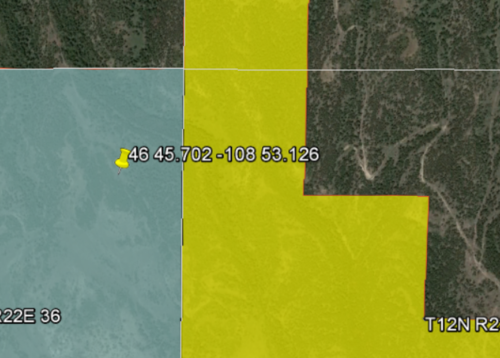
Below is a link that starts Gmap4 and shows that those coordinates (46 45.702 -108 53.126) are at least 400 feet inside private property. Zoom in more and you will see the 2-track that apparently the cat was working on.
The BLM ownership data shown on this map is available from various GIS servers run by the feds. The link below gets this data from the GeoMAC server since it seems fairly speedy.
For more info about GeoMAC see: http://www.geomac.gov/about.shtml
http://www.mappingsupport.com/p/gma...name=Meridians&layers=0,4,13&transparent=true
Joseph
onX Hunt
Active member
- Joined
- Jul 22, 2013
- Messages
- 387
Joseph,
I have the coordinates but will not be sharing them, I have been hunting this spot for 14 years and hope to keep it a secret. This was for a hunt on a different area that borders the Wilks land.
I just wanted to point out that typically I have been able to find property lines/pins within the accuracy of a recreational GPS, as long as the data that is used to make the map is accurate as has been pointed out here. It appears the data for this area of their ranch is fairly accurate. The distance between my location on my GPS and the actually location I was standing at was 15 feet apart. I would expect that to fluctuate as my GPS signal changes but it does give a good idea of what can be expected when it all comes together as planned.
Matt
Thanks for posting coordinates. I suspect this discussion would benefit if more people did so.
Below is a link that starts Gmap4 and shows that those coordinates (46 45.702 -108 53.126) are at least 400 feet inside private property. Zoom in more and you will see the 2-track that apparently the cat was working on.
The BLM ownership data shown on this map is available from various GIS servers run by the feds. The link below gets this data from the GeoMAC server since it seems fairly speedy.
For more info about GeoMAC see: http://www.geomac.gov/about.shtml
http://www.mappingsupport.com/p/gma...name=Meridians&layers=0,4,13&transparent=true
Joseph
Jelf, I am interested in your professional opinion, given you seem to have a lot of insight to this. The link you provided, how reliable/accurate/inaccurate do you see those boundaries being?
I suspect without an official survey, it is impossible to answer, but curious if you have a professional opinion on the information shown at that link. Thanks in advance for anything you can shed light on.
onX Hunt
Active member
- Joined
- Jul 22, 2013
- Messages
- 387
katqanna
Well-known member
I was just reminded today that I had not uploaded and posted the BLM Realty Trespass Abatement Handbook that Utah sent me. I had wanted to read through it first to see if it was applicable, finally read it on Sat. and there are many aspects applicable, which I will have to type out later. I have been on the phone with agencies and hunters this morning, and getting ready to go back to the Durfees for a few day documentation trip, not just an afternoon.
I just spoke with Melody Lloyd from BLM Billings. She stated they were planning on sending the Cadastral survey crew in to the Durfees tomorrow, which depending on weather, might take about 2 weeks. I asked if they were intending on shutting down hunting while they were out, Melody stated that was up to FWP, that their survey crew would be wearing hunter orange for safety. She suggested that we "Like" their Montana BLM facebook page for updates and notifications.
I called Lewistown FWP office to see if they were closing the Durfees to hunting due to the BLM Cadastral survey crew and she was not aware of any such hunting closures.
Still, nobody can tell me if my or any other concerned person reporting any violation connected with this fencing issue (whether possible encroachment, fence construction, Unlawful Inclosures, ground disturbance, damage to public property, caterpillar, etc.) has produced the required Form 9230-10 that is the first step in this process, per PDF page 41 & 42 (IV-5,6 BLM pages),
As I explained in 3 BLM conversations now, this is recorded as being the first step once discovery is made and reported, which I have done in written form, providing my contact info. I know others have called BLM, but I dont know if they had to provide any written statements. So at the very least, there should have been one of these forms produced when I wrote Jamie Connell asking about a survey to establish fence boundary and investigation into the fencing construction.
As I have also pointed out in several BLM conversations, BLM trespass handbook PDF page 27 (BLM II-1) states under
I just spoke with Melody Lloyd from BLM Billings. She stated they were planning on sending the Cadastral survey crew in to the Durfees tomorrow, which depending on weather, might take about 2 weeks. I asked if they were intending on shutting down hunting while they were out, Melody stated that was up to FWP, that their survey crew would be wearing hunter orange for safety. She suggested that we "Like" their Montana BLM facebook page for updates and notifications.
I called Lewistown FWP office to see if they were closing the Durfees to hunting due to the BLM Cadastral survey crew and she was not aware of any such hunting closures.
Still, nobody can tell me if my or any other concerned person reporting any violation connected with this fencing issue (whether possible encroachment, fence construction, Unlawful Inclosures, ground disturbance, damage to public property, caterpillar, etc.) has produced the required Form 9230-10 that is the first step in this process, per PDF page 41 & 42 (IV-5,6 BLM pages),
"D. Case Proceeding: Each realty trespass case requires certain actions (i.e., processing steps) from initiation to case closure. Each action should be fully explained and documented in the case file in chronological order. The following is a description of the general processing steps for a typical realty trespass case and the identification of Bureau specialists or managers normally responsible for each.
Step 1. Record who made discovery, address, telephone number, what was observed, who is suspected, etc., on Form 9230-10, and attach written statements as necessary. Preserve private citizen confidentiality as appropriate."
As I explained in 3 BLM conversations now, this is recorded as being the first step once discovery is made and reported, which I have done in written form, providing my contact info. I know others have called BLM, but I dont know if they had to provide any written statements. So at the very least, there should have been one of these forms produced when I wrote Jamie Connell asking about a survey to establish fence boundary and investigation into the fencing construction.
As I have also pointed out in several BLM conversations, BLM trespass handbook PDF page 27 (BLM II-1) states under
"Employee Responsibilities, 1. All Bureau Employees: a. Knowing how to report, and reporting, incidents of trespass or suspected trespass observed during the performance of assigned duties or functions. For the purpose of reporting incidents of trespass, employees shall record all occupancy, use, and development as if it is unauthorized, pending a determination that the use, occupancy, or development has been authorized by the Bureau."
Last edited:
Elkmagnet
Well-known member
I just read this entire thread in one sitting. When I read the 15th page I literally went and started some popcorn.
I really find it disturbing that the blm gave them the benefit of the doubt on everything until proven otherwise.
I hope they are held to the letter of the law. These things although tactful were obviously done out of spite.
I really find it disturbing that the blm gave them the benefit of the doubt on everything until proven otherwise.
I hope they are held to the letter of the law. These things although tactful were obviously done out of spite.
I don't know how hard it is to prove knowingly, but for every posted sign with BLM proven to be behind it:
45-8-115. Illegal posting of state and federal land. (1) A person commits the offense of illegal posting of state or federal land if, without authorization, the person knowingly posts land that is under the ownership or control of the state or federal government to restrict access or use of state or federal land.
(2) A person convicted of illegal posting of state or federal land shall be fined an amount not to exceed $500 or be imprisoned in the county jail for a term not to exceed 6 months, or both.
Last edited:
RobertR
Member
Not sure if some have read the latest article on the Wilkes Bros.
http://helenair.com/news/local/stat...cle_1a21d156-318e-587c-afac-9159765e9bc7.html
http://helenair.com/news/local/stat...cle_1a21d156-318e-587c-afac-9159765e9bc7.html
sneakypete
Well-known member
- Joined
- May 19, 2014
- Messages
- 1,866
RobertR , thanks for posting the article!
katqanna
Well-known member
Robert, thank you for posting that. That is similar to the map I saw on Monday that I mentioned and wanted to update. This one appears updated to August at least. This might save me some trouble. Wish it had a link to a larger pdf copy.
RobG
Well-known member
Not sure if some have read the latest article on the Wilkes Bros.
http://helenair.com/news/local/stat...cle_1a21d156-318e-587c-afac-9159765e9bc7.html
“We got a lot of calls,” Benes said. “Now we can say, ‘Hey we hear you and are going to go out and get a survey.’ Since then, the clamor has eased up.”
Yup, the survey sure took everyone's mind off of the fact that the BLM initially tried to intimidate the hunters with increased enforcement while "not seeing" all the illegal activity documented by Wingman and others. Keep it quite until the elections are over... People might want to do a little poking around and make some noise and try to solve that little BLM accountability problem...
For example, why hasn't the BLM issued a press release stating that the hunters were correct and their own staff is so incompetent they didn't realize the fence was illegal under MT law and BLM's own laws?
Kat is doing her work telling us what the problems are and I think the rest of us should write BLM's Jamie Connell, Tester, Baucus, Daines, the commissioners, the press, and shit I don't know maybe the Pope. Seems like this issue should be getting more sunshine to accomplish something meaningful but I suppose some will be happy to look at that fence twenty years from now and say "See that there bottom wire? It used to be four inches lower like most fences in MT, but I raised one hell of a firestorm and got it moved up to where it is now. Now aren't you proud of me son?"
Just my opinion...
Similar threads
- Replies
- 15
- Views
- 2K
- Replies
- 54
- Views
- 6K
