Paul in Idaho
Well-known member
On Saturday I was headed up to glass some potential new elk hunting spots. I happened to see a light-colored rock on a different mountain, so I stopped to look. It turned out that rock was a big bull elk. Plans changed.
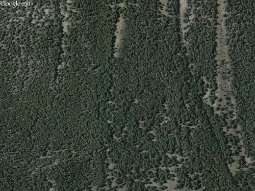
I spent the next 7 hours hiking that mountain. Elk sign was everywhere. Elk trails, rubs, fresh tracks. They live there, somewhere. The problem is, the mountain seems to be the same all over - just uniformly dense timber with a very few open areas of grass. One of those is where the bull had been. I never caught up to him, but did manage to find that park. I also had a cow and calf come close to me before a swirl of wind sent my scent the wrong way.
What I didn't find was any sign of water. No creek, no seep or wallow. Nothing.
With all those hundreds of acres of timber, I need a way to focus my efforts. Water seems to be a likely option. Can you offer any suggestions on how to locate a water source when none is shown on a USGS topo map? I presume starting on the north face would be good, but beyond that I'm stumped. The topo map shows a couple little cirque lakes not far off, but Google Earth shows they are dry in September.
Here's a pic from Google Earth of the mountain.

Thanks.
I spent the next 7 hours hiking that mountain. Elk sign was everywhere. Elk trails, rubs, fresh tracks. They live there, somewhere. The problem is, the mountain seems to be the same all over - just uniformly dense timber with a very few open areas of grass. One of those is where the bull had been. I never caught up to him, but did manage to find that park. I also had a cow and calf come close to me before a swirl of wind sent my scent the wrong way.
What I didn't find was any sign of water. No creek, no seep or wallow. Nothing.
With all those hundreds of acres of timber, I need a way to focus my efforts. Water seems to be a likely option. Can you offer any suggestions on how to locate a water source when none is shown on a USGS topo map? I presume starting on the north face would be good, but beyond that I'm stumped. The topo map shows a couple little cirque lakes not far off, but Google Earth shows they are dry in September.
Here's a pic from Google Earth of the mountain.

Thanks.


