Ttannahill14
Active member
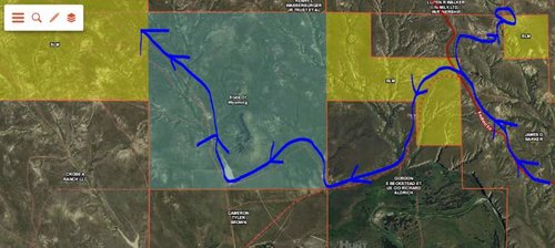
Attached an image as reference, just to make sure I'm scouting correctly. Not saying I'm hunting anywhere near this spot I just picked a location that I could ask a few questions off of. I've never been to this area of Wyoming so just want to make sure I'm understanding the rules/regs and maps.
So if i'm heading northwest on Redbird Road, I could access that small portion of BLM in the upper right corner via that small road even though that road is through private ground. Correct?
Also if I were to turn left and head toward that larger section of BLM, then leave that BLM land on that same road while heading into private ground but staying on the road with a vehicle. Then re-enter the state land while staying on the road, and finally enter into the BLM land in the upper left corner of the map. Obviously staying on the roads whether i'm on private or public if I'm in a vehicle. And pulling over and walking/hunting if i'm on BLM or State land.
ALso camping on BLM land questions?... just pull over to the shoulder of the road and pick a spot and set up camp? Correct? That just seems wrong with my Midwestern brain haha.
Also theres many roads listed on OnX maps... yet when I look on google earth they look like they barely exist. Is a road a road no matter how faint it might be? Public/private doesn't matter as long as I'm in the vehicle I have a right to that road?
Hope this all makes sense. Just trying to avoid being an ignorant hunter...


